Overview
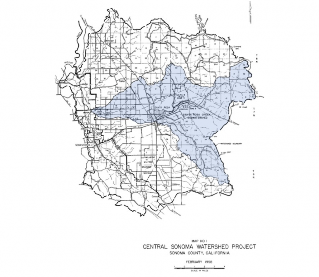
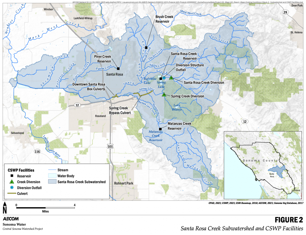
In 1958, the Sonoma County Flood Control and Water Conservation District (now Sonoma Water) and the USDA Soil Conservation Service (now Natural Resources Conservation Service [NRCS]) developed the Central Sonoma Watershed Work Plan (1958 Plan) to combat recurring flood damage in Sonoma County. The 1958 Plan covered 163,000 acres of the Laguna de Santa Rosa, Mark West, and Santa Rosa Creek watersheds (Figure 1); however, it explicitly focused on mitigating flooding in the 50,000-acre Santa Rosa Creek subwatershed through an integrated network of channels, detention reservoirs, and diversion structures (flood facilities) that were completed between 1962 and 1988. Collectively, these flood facilities are known as the Central Sonoma Watershed Project (CSWP). Sonoma Water maintains and operates the CSWP, which includes facilities along Santa Rosa, Matanzas, Paulin, Spring, and Brush Creeks that protect the City of Santa Rosa and surrounding rural areas (Figure 2).
The CSWP has exceeded its original 50-year design life and needs a comprehensive system-wide assessment to ensure it can reliably mitigate flood hazards in the City of Santa Rosa and surrounding unincorporated areas for future generations. Given the age of CSWP facilities, development and land-use changes that have occurred over the last 60 years, population growth, and newly available seismic risk and future climate data, Sonoma Water has entered into a cooperative funding agreement with the NRCS to conduct a vulnerability assessment of CSWP facilities and to develop a new Watershed Plan – Environmental Document (Watershed Plan-ED) under the Public Law 83-566 (PL-566) Program. The purpose of the Watershed Plan-ED is to identify and evaluate feasible alternatives that restore or improve flood protection and mitigate vulnerabilities to increase community resilience over the next 50 years. The Watershed Plan-ED will document potential costs, benefits, and environmental impacts of the alternatives.
As the Federal Lead Agency, NRCS will assist Sonoma Water and publish a combined Watershed Plan – Environmental Document (Watershed Plan – ED) that complies with the National Environmental Policy Act (NEPA). Sonoma Water will complete a separate California Environmental Quality Act, AB 52, and state and federal regulatory permit process.
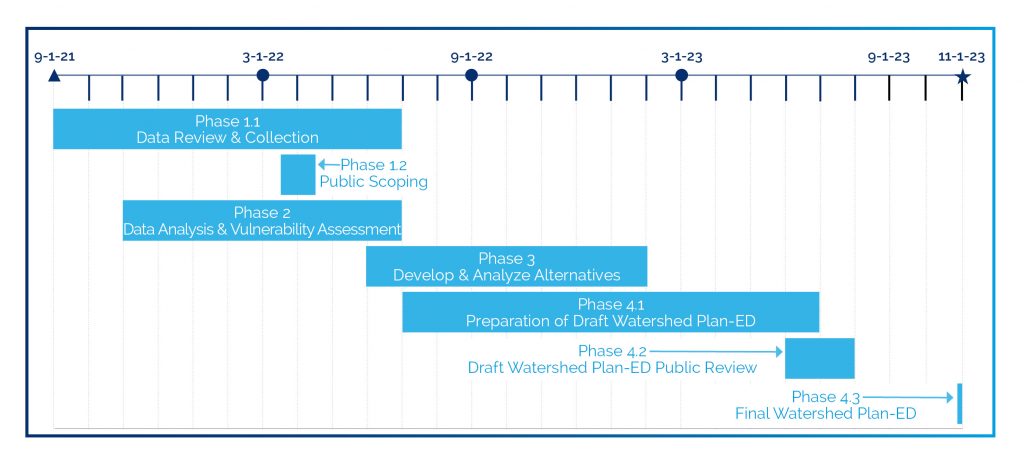
Schedule
Scoping
The NEPA process includes an early and open process to determine the scope of issues for analysis; this process is termed scoping. The scoping process for this Watershed Plan-ED will include public meetings and a comment period when the public can submit information, comments, and concerns to consider during development of the Watershed Plan-ED. During this period, the public may provide comments via this website, email, or mail (see How to Comment section below). In addition to comments and input provided by the public, per Title 390 – National Watershed Program Manual Part 501.24, scoping must consider, but is not limited to, the following:
- National Economic Development (NED) Principles and Guidelines
- Air quality
- Coral reefs
- Cultural resources
- Ecologically critical areas
- Endangered and threatened species
- Environmental justice and civil rights
- Essential fish habitat
- Fish and wildlife (including coordination requirements)
- Floodplain management
- Forest resources
- Invasive species
- Land use
- Migratory birds
- Natural areas
- Parklands
- Prime and unique farmland, and farmland of statewide significance
- Public health and safety
- Regional water resource plans (including coastal zone plans)
- Riparian areas
- Scenic beauty
- Scientific resources
- Sole source aquifers
- Social issues
- Soil resources
- Water quality
- Water resources
- Waters of the United States, including special aquatic sites
- Wetlands
- Wild and scenic rivers
- Other concerns identified by Sponsoring Local Organization, agencies, and the public
Public Involvement
Sonoma Water and NRCS seek your input, comments, and concerns and welcome public involvement in this early phase of the planning process. No alternatives are currently being considered for implementation. Individuals and entities may get involved and obtain additional information by attending the public scoping meeting listed below. You may also submit a comment via email, mail, or through this website.
Public Scoping Meeting
- Date: Wednesday, April 6, 2022
- Time: 6:30 p.m. – 7:30 p.m.
- Place:
- Online at Zoom.us
How To Comment*
- Submit comments on the map below:
- Send an email to:
- Mail comments to the following address:
- Jones & DeMille Engineering
- Attn: Jenna Jorgensen
- 1535 S. 100 W., Richfield, UT 84701
* Comments will be accepted through the project website, email, and mail between March 21, 2022, and April 21, 2022, 11:59 PM (PST). Mailed comments will be accepted if postmarked by April 21, 2022.
Public Comment + Map
Questions & Comments Can Be Directed To:
- Jenna Jorgensen – Public involvement contact: (435) 896-8266
- Susan Haydon – NRCS Liaison: Susan.Haydon@scwa.ca.gov
- Aaron Fulton – Sonoma Water Project Manager: Aaron.Fulton@scwa.ca.gov